
DOCUMENT 05 - MAP OF HEIGHT REGULATION
Denebolian Ministry of Urban Development
Introduction
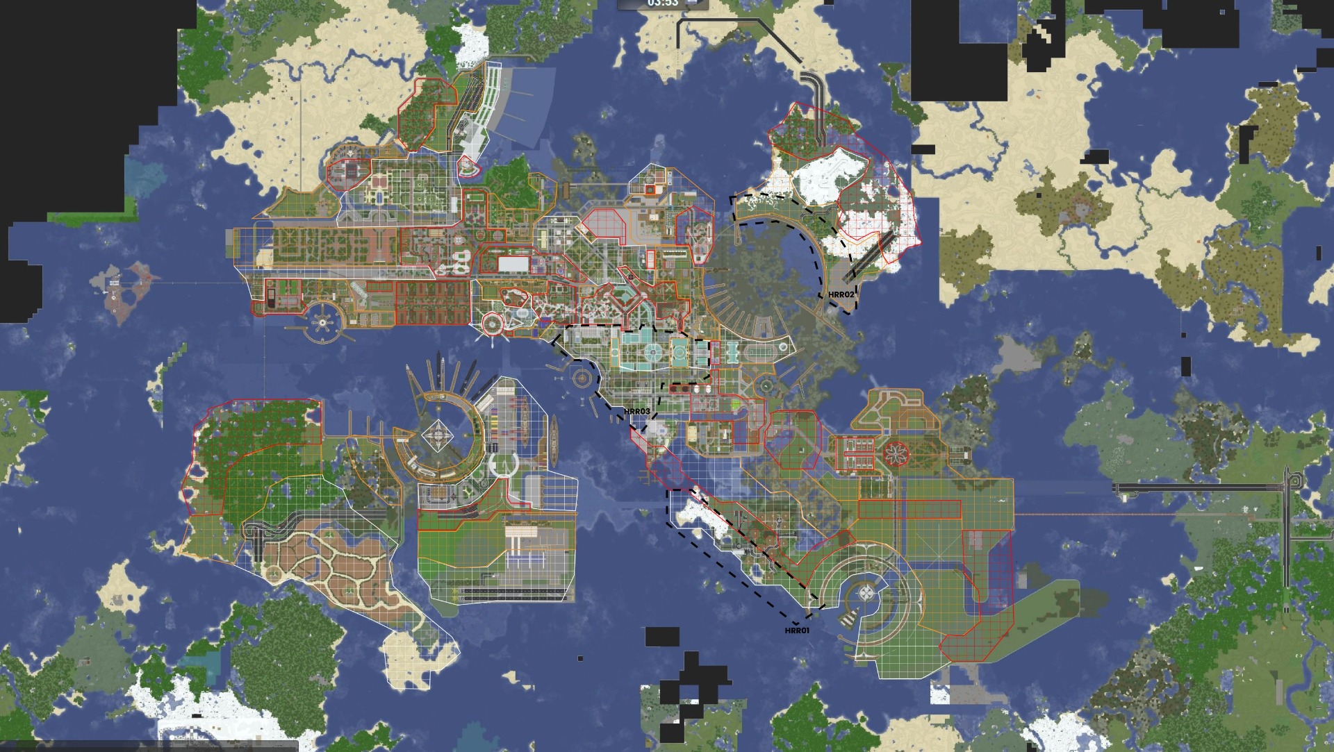
The Map of Height Regulation forms the fifth regulatory layer of the Denebol Prime Metropolitan Plan. It defines where low-height, medium-height and high-rise buildings are allowed across the city.
The map should be read together with its regulatory description. The map determines the spatial extent of each height category, while the legal text explains the height limits, high-rise restrictions and assessment principles for future development.
Height regulation is especially important in transformation areas, waterfronts, district centres and historically sensitive locations. It ensures that new development can increase density where appropriate, while protecting the city's skyline, protected buildings and visual relationships across waterways.
High-rise restricted areas HRR01, HRR02 and HRR03 create a stricter layer of protection. Where these areas overlap with other height categories, the high-rise ban prevails.
The uploaded height map marks the three high-rise restricted areas and the red, orange and white height grids across Denebol Prime.
Leave a message
Legal Attachment
Regulatory Description of Building Height Categories, High-Rise Areas abd High-Rise Restricted Areas
Article I. - Purpose of the Document
- The Map of Height Regulation forms the fifth regulatory layer of the Denebol Prime Metropolitan Plan.
- The purpose of this document is to regulate the height structure of Denebol Prime and to protect the city skyline, historic urban context, waterfront views and important visual corridors.
- This document identifies areas where high-rise buildings are allowed, areas where medium-height buildings are allowed, areas where only low-height buildings are allowed and areas where high-rise buildings are expressly banned.
- The document shall guide future development, reconstruction, transformation areas, urban studies and district-level planning.
- The height regulation applies to new buildings, major reconstruction, vertical extensions and significant changes to the massing of existing buildings.
Article II. - Relation to the Metropolitan Plan
- This document shall be read together with the other documents of the Denebol Prime Metropolitan Plan.
- Where the Map of Transformations identifies areas of future development, this document defines the permitted height framework for such development.
- Where the Map of Architectural Values identifies protected buildings and architectural areas, this document shall support the protection of their urban context and visual setting.
- Where the Map of Transportation Development identifies stations and transport corridors, this document may allow higher development where compatible with the height category shown on the map.
- Where a high-rise restricted area overlaps with a high-rise allowed area, the high-rise restriction shall prevail.
Article III. - Interpretation of the Map
The Map of Height Regulation identifies height categories by grid colour.
- The red grid identifies areas where high-rise buildings are allowed.
- The orange grid identifies areas where medium-height buildings are allowed, with a maximum height of 10 floors.
- The white grid identifies areas where low-height buildings are allowed, with a maximum height of 4 floors.
High-rise restricted areas are identified by codes beginning with the prefix "HRR". The map determines the spatial extent of height categories and high-rise restricted areas. This text determines their regulatory meaning.
Article IV. - Definition of Building Height Categories
- A low-height building is a building with a maximum of 4 floors.
- A medium-height building is a building with a maximum of 10 floors.
- A high-rise building is a building exceeding the maximum height of medium-height buildings, unless a stricter rule applies under another document or specific area regulation.
- Technical rooftop elements, towers, antennas, domes, spires, monuments or other special structures may be assessed individually where they do not function as regular building floors.
- Underground floors are not counted as floors for the purpose of this document.
- Mezzanine levels, technical floors and partially open floors shall be counted where they visually or functionally contribute to the height of the building.
Article V. - General Height Regulation Principles
- Building height shall be used to support the legibility, density and spatial hierarchy of the city.
- Taller buildings should be located where they strengthen metropolitan centres, transport nodes, major development areas or strategic urban axes.
- Lower buildings shall be used to protect historic buildings, waterfront views, landscape edges, local neighbourhood character and important public spaces.
- High-rise development shall not visually dominate historically protected buildings unless expressly permitted by an approved urban study.
- The transition between height categories shall be designed gradually where possible.
- New development shall respect important views from waterways, bridges, waterfronts and public spaces.
- Height regulation shall not be interpreted only as a maximum technical limit. It shall also guide the intended character of each area.
Article VI. - Height Categories
High-Rise Building Areas
- High-rise building areas are shown by the red grid.
- High-rise buildings are allowed in these areas.
- High-rise development shall be subject to urban-design assessment where it affects major public spaces, waterfronts, protected buildings or skyline views.
- High-rise buildings shall provide a clear urban role, such as forming a centre, landmark, gateway, transport-node intensification or strategic development focus.
- High-rise buildings shall not be placed in a manner that blocks important view corridors or weakens the legibility of protected historical structures.
- In high-rise areas, lower buildings remain allowed where they support the intended urban structure.
Medium-Height Building Areas
- Medium-height building areas are shown by the orange grid.
- Buildings in these areas may have a maximum of 10 floors.
- Medium-height areas are intended for compact urban development, district centres, mixed urban structures and areas requiring stronger density without high-rise dominance.
- Buildings above 10 floors are not allowed in medium-height areas unless the map is amended or a special exception is granted under the governance rules of the Metropolitan Plan.
- Medium-height development shall respect adjacent low-height areas and shall provide appropriate transition where required.
Low-Height Building Areas
- Low-height building areas are shown by the white grid.
- Buildings in these areas may have a maximum of 4 floors.
- Low-height areas are intended to protect local character, historic context, landscape edges, waterfront visibility, smaller-scale urban fabric and sensitive areas.
- Buildings above 4 floors are not allowed in low-height areas unless a later plan amendment changes the height category.
- Low-height regulation shall not prevent the construction of civic buildings, monuments or special structures where their height is individually justified and does not conflict with the purpose of the area.
Article VII. - Hihg-Rise Restricted Areas
General Regulation of High-Rise Restricted Areas
- High-rise restricted areas are marked by the prefix "HRR".
- High-rise buildings are banned in high-rise restricted areas.
- The purpose of high-rise restricted areas is to protect historical buildings, their urbanistic context and waterway view sides.
- The restriction applies even where a surrounding or underlying grid would otherwise allow higher development.
- Medium-height or low-height development may be allowed within high-rise restricted areas only where compatible with the protected context and the relevant height category.
- Any development in a high-rise restricted area shall be assessed in relation to protected buildings, waterfront views, skyline views and surrounding public spaces.
Area HRR01
- High-rise buildings are banned in HRR01.
- The area is protected due to the urbanistic context of significant buildings and the need to preserve waterway view sides.
- Future development shall maintain a height scale compatible with the surrounding context and shall not create visual dominance over protected or representative structures.
Area HRR02
- High-rise buildings are banned in HRR02.
- The area is protected due to the relationship between historical buildings, surrounding urban structure and waterway views.
- Future development shall preserve the visual openness and spatial legibility of the area.
Area HRR03
- High-rise buildings are banned in HRR03.
- The area is protected due to the need to preserve historical urban context and important waterway view sides.
- Future development shall not reduce the visibility, prominence or spatial setting of protected buildings and public spaces.