The Ministry of Urban Development is the leading governmental authority overseeing urban planning, smart infrastructure, and sustainable city growth across the Denebolian Republic. The ministry ensures that all cities, settlements, and public spaces reflect modern technological advancements while respecting historical heritage and cultural identity.
MUD is responsible for shaping the future of Denebolian cities, ensuring that every development meets the highest standards of efficiency, sustainability, and accessibility. By integrating artificial intelligence, self-repairing nanite structures, and adaptive planning, the ministry guarantees that all urban expansion remains harmonized with the environment and the needs of citizens.
Whether through smart zoning policies, green urbanization projects, or historic preservation efforts, MUD plays a vital role in the long-term vision of Denebol Prime and beyond. The ministry's policies and projects reflect a balance between innovation and tradition.
Through carefully structured development plans, MUD defines what can be built, where, and how, ensuring that urban expansion is strategic, well-planned, and beneficial to all.
Current minister: Ing. arch. Martin Thomas Novak, Ph.D.
"Building the Future, Honoring the Past"
List of updates
20.05.2026 - Enactment of Metropolitan Plan DRL200526MP
18.05.2026 - Presentation of revised Metropolitan Plan DRL180526MP
05.05.2026 - Metropolitan Plan declined
29.04.2026 - Presentation of the Metropolitan Plan DRL290426MP
15.02.2025 - Enactment of the Development Plan DRL150225DP
01.01.2025 - Development Plan approved
20.01.2025 - Presentation of revised Development plan DRL200125DP
05.01.2025 - Development Plan declined
01.01.2025 - Presentation of the Development Plan DRL010125DP
Denebol Prime Metropolitan Plan
DRL200526MP
The Denebol Prime Metropolitan Plan introduces a new planning framework for the long-term development of the capital city. It replaces the current Basic Development Plan and Development Map with a more detailed, structured and legally readable system of planning documents.
The existing development framework was created under the authority of the Ministry of Urban Development, which oversees city planning, zoning, infrastructure, environmental protection and sustainable urban growth across the Denebolian Republic. The current Development Map already serves as a legally binding framework for zoning, infrastructure and transportation planning.
As Denebol Prime continues to expand, the city requires a more precise instrument. The Metropolitan Plan divides the planning process into several separate documents. Each document focuses on a specific layer of urban development, including transformation areas, land-use structure, transport infrastructure, public spaces, landscape systems and district-level planning.
The purpose of the Metropolitan Plan is not only to define what can be built, but also to explain how individual parts of the city should develop over time. It distinguishes stable districts, areas of gradual improvement and major transformation zones. This makes the plan easier to read, easier to update and more useful for future development.
The Metropolitan Plan therefore becomes the new principal planning document for Denebol Prime. Older development documents remain relevant as historical and preparatory material, but their regulatory role will be gradually replaced by the new metropolitan planning system.
You can use the interactive Denebolian Geoinformation System below, or explore each document individually. Legal attachements and broader descriptions are listed below the interactive viewer for each individual document.
MINISTRY OF URBAN DEVELOPMENT
Document 01 - Map of Transformations
The Map of Transformations is the first document of the Denebol Prime Metropolitan Plan. It identifies which parts of the city are considered stable, which areas are expected to undergo minor development and which areas are reserved for major transformation.
The map uses three basic categories. White areas represent completed or stabilized parts of the city, where no major development is expected. Orange areas mark locations with smaller interventions, ongoing projects or gradual local improvement. Red areas identify territories where significant urban, landscape or infrastructural transformation is expected.
This document does not define the final shape of every building or district. Its main purpose is to provide a clear overview of where future change will happen. Detailed regulation will follow in later documents and urban studies.
The Map of Transformations is divided by city districts and uses area codes for easier orientation. Each marked area is then described in the legal attachment, which defines its planning status, expected type of transformation, study requirement and admissible functions.
Document 02 - Map of Architectural Values
The Map of Architectural Values is the second document of the Denebol Prime Metropolitan Plan. It defines the architectural, historical and landscape values that should guide future development of the city.
Unlike district-based planning documents, this map works across district borders. It identifies architectural areas according to their character, material logic, public-space structure and historical importance. Each area is marked with its own code, which links the map to the legal description of the document.
The document also identifies biocorridors, green areas and significant buildings with historical protection. These elements form an important part of the city's identity and must be considered in future development, reconstruction, infrastructure works and public-space design.
The purpose of the Map of Architectural Values is not to stop the city from changing. Its role is to make sure that future changes respect the existing character of Denebol Prime, protect important buildings and strengthen the architectural coherence of individual parts of the city.

Document 03 - Map of Transportation Development
The Map of Transportation Development is the third document of the Denebol Prime Metropolitan Plan. It defines the main transport structure of the capital and protects the corridors, stations and transport points needed for the city's future growth.
The map identifies existing and future subway lines, maglev corridors, present and planned stations, stations intended for reconstruction and important transport points. It also defines restricted no-fly zones, which regulate civilian, military, government and international air traffic above selected parts of the city.
This document connects the city's spatial development with its transport capacity. It ensures that future districts can be served by public transport, that important corridors remain protected and that major infrastructure can be built in stages without being blocked by later development.
The Map of Transportation Development does not determine the final technical form of every line or station. It establishes the strategic framework. Detailed alignments, station design and interchange solutions will be developed through later transport studies, infrastructure projects and district-level plans.
Document 04 - Map of Public Infrastructure
The Map of Public Institutions is the fourth document of the Denebol Prime Metropolitan Plan. It identifies the main public, civic and strategic buildings that support the daily operation, safety and representative role of the capital city.
The map includes education buildings, military facilities, fire department buildings, Denebolian Police Force buildings, government institutions, hospitals, diplomatic buildings and embassies, cultural buildings, banks and transportation buildings. Each type is marked by a distinct colour for clear orientation.
The document also identifies three major institutional development areas: BL01 Borrowland, SP01 West Islands and HB01 Bay Horn. These areas are expected to grow significantly and must therefore include new public institutional buildings as part of their future development.
The purpose of this document is not to define every building plot in detail. Its role is to protect existing institutions, identify missing public infrastructure and ensure that future districts are not built without schools, healthcare, emergency services, government facilities, transport buildings and other essential civic functions.

Document 05 - Map of Height Regulation
The Map of Height Regulation is the fifth document of the Denebol Prime Metropolitan Plan. It defines the permitted height structure of the city and protects the skyline, historical context and important views from waterways and public spaces.
The map divides the city into three main height categories. Red grid areas allow high-rise buildings. Orange grid areas allow medium-height buildings, with a maximum of 10 floors. White grid areas allow low-height buildings, with a maximum of 4 floors.
The document also identifies high-rise restricted areas HRR01–HRR03. In these areas, high-rise buildings are banned to protect historically significant buildings, their urban context and important waterway view sides.
The purpose of this document is not only to limit building height, but to guide the visual structure of Denebol Prime. It helps define where the city can grow vertically, where a lower urban scale should remain, and where views and historical settings must remain protected.

Document 06 - Map of Urban Structure and Centres
The Map of Urban Structure and Centres is the sixth document of the Denebol Prime Metropolitan Plan. It defines the main hierarchy of centres that shape the city's structure, identity and future development.
The map identifies cultural centres, transport centres, natural and park centres, local and special centres, strategic centres, historical centres and the metropolitan centre. These centres do not only mark important places. They help guide the design of pathways, public spaces, connections, density and the relationship between districts.
Some districts contain several centres of one type, while others intentionally contain none. Historical, metropolitan, special and strategic centres may also cross district boundaries, because their importance is defined by their urban role rather than by administrative borders.
The purpose of this document is to make Denebol Prime easier to read and plan. It defines where local life should concentrate, where transport connections should be strengthened, where public spaces should become more important and where historical or representative parts of the city require special protection.

Document 07 - Implementation and Governance
Legislation
Implementation and Governance is the seventh document of the Denebol Prime Metropolitan Plan. Unlike the previous documents, it is not a map. It defines how the whole planning system is interpreted, applied, reviewed and updated.
This document establishes the legal hierarchy between all parts of the Metropolitan Plan. It explains how the Map of Transformations, Map of Architectural Values, Map of Transportation Development, Map of Public Institutions, Map of Height Regulation and Map of Urban Structure and Centres should work together.
It also defines the role of public authorities, including the Ministry of Urban Development, Ministry of Culture & Agriculture, transport authorities, security authorities and other institutional bodies. These authorities review urban studies, protected buildings, historical centres, transport corridors, public institutions, no-fly zones and strategic areas.
The purpose of this document is to make the Metropolitan Plan usable in practice. It defines how urban studies are approved, how exceptions can be granted, how amendments are made and how development should proceed in both transformation and stable areas.
Urban Development & Heritage Protection Act (DRL042524UD)
The Urban Development & Heritage Protection Act establishes zoning laws, construction standards, and historical preservation regulations across the Denebolian Republic. It mandates minimum building heights, green infrastructure, full transit accessibility, and AI-driven urban planning while ensuring protected historical sites are preserved and marked with stone monuments. This act shapes sustainable, efficient, and future-proof cities while respecting Denebolian heritage.
!Following section is outdated and serves only for historical purposes!
DENEBOL PRIME DEVELOPMENT PLAN
Denebol Prime Development Strategies (REPLACED BY METROPOLITAN PLAN)
Basic Development Strategy
The Basic Strategy builds upon the foundation laid by the Development Map. Its purpose is to create a dynamic and adaptable urban environment that supports a high quality of life for Denebolian citizens.
Goals of BD Strategy:
Prioritizing eco-friendly technologies and energy-efficient buildings, integrating green spaces, and ensuring resource management meets the demands of future generations. Encouraging the use of advanced technologies in construction, utilities management, and public services to improve efficiency, safety, and citizen engagement. Collaborating with private enterprises to stimulate innovation, while ensuring that developments adhere to the public welfare, environmental standards, and zoning laws. Ensuring that urban growth complements and preserves Denebolian heritage and culture by carefully incorporating new developments into existing cityscapes and historical areas. Promoting affordable housing, equitable access to public spaces, and services that meet the needs of all citizens, ensuring that the development benefits every demographic.
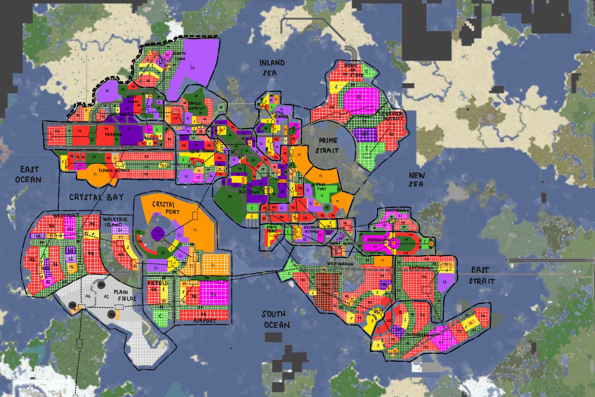
BDP Legend
- HB – Residential Buildings (Housing areas, apartment complexes, private homes)
- S – Services and Trade Companies (Shops, commercial centers, private businesses, offices)
- GB – Government Buildings (Administrative offices, parliament, city halls)
- GI – Government Institution Buildings (Ministry offices, law enforcement, research centers)
- AG – Agriculture (Farms, hydroponic facilities, food production zones)
- PP – Public Spaces/Parks (Green areas, plazas, recreational spaces, nature reserves)
- ES – Education and Sports (Schools, universities, training centers, stadiums, sports complexes)
- C – Culture (Museums, theaters, historical landmarks, libraries, event centers)
- TI – Transport Infrastructure (Subway stations, maglev routes, transporter hubs, pedestrian roads, highways, spaceports)
Basic Development Plan (REPLACED BY METROPOLITAN PLAN)
The Development Map serves as a legally binding framework that governs the growth and expansion of Denebolian cities. This comprehensive document outlines zoning regulations, infrastructure development, and transportation networks, ensuring that all urban activities are in harmony with the Republic's environmental sustainability policies.
The Development Map guarantees that all new construction projects adhere to the urban planning principles set by the Denebolian Republic. It ensures that city growth is not only practical and sustainable but also respects the heritage of existing structures and the environment.
Click on the picture for zoom.