
DOCUMENT 06 - MAP OF URBAN STRUCTURE & CENTERS
Denebolian Ministry of Urban Development
Introduction
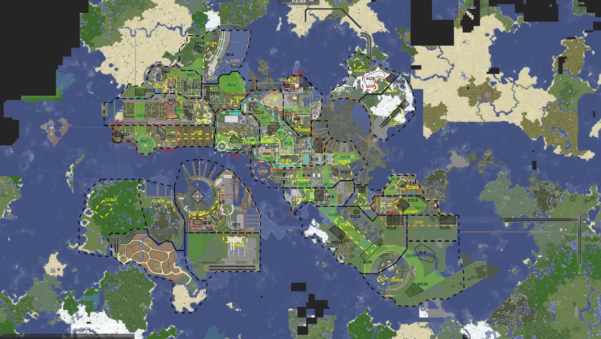
The Map of Urban Structure and Centres forms the sixth regulatory layer of the Denebol Prime Metropolitan Plan. It identifies the central places of Denebol Prime and defines their role within the broader city structure.
The map should be read together with its regulatory description. The map defines the location and type of each centre, while the legal text explains how these centres should influence public spaces, pathways, density, transport access and development priorities.
Centres are divided into several categories: cultural centres, transport centres, natural and park centres, local and special centres, strategic centres, historical centres and the metropolitan centre. Each category has a different planning role and a different level of protection or importance.
Historical centres are subject to stricter review by both the Ministry of Urban Development and the Ministry of Culture & Agriculture. The metropolitan centre represents the main city centre and must reflect the representative role of Denebol Prime as the capital city.
Leave a message
Legal Attachment
Regulatory Description of Cultural, Transport, Natural, Local, Special, Strategic, Historical and Metropolitan Centers
Article I. - Purpose of the Document
- The Map of Urban Structure and Centres forms the sixth regulatory layer of the Denebol Prime Metropolitan Plan.
- The purpose of this document is to define the spatial hierarchy of Denebol Prime through a system of centres, central areas and strategic urban nodes.
- This document identifies cultural centres, transport centres, natural and park centres, local and special centres, strategic centres, historical centres and the metropolitan centre.
- The centres designated by this document are intended to guide the planning of pathways, public spaces, connections, density, institutional placement and district identity.
- The document does not assign detailed land use to every plot. It defines the intended role and hierarchy of places within the city structure.
Article II. - Relation to the Metropolitan Plan
- This document shall be read together with the other documents of the Denebol Prime Metropolitan Plan.
- Where the Map of Transformations identifies areas of future change, this document identifies the centres and structural nodes that such transformation shall support.
- Where the Map of Architectural Values defines architectural character and protected buildings, this document defines the urban role of the surrounding centre or central area.
- Where the Map of Transportation Development identifies corridors and stations, this document identifies transport centres and areas where interchange, access and public-space intensity shall be strengthened.
- Where the Map of Public Institutions identifies civic buildings, this document shall guide their relationship to local, cultural, strategic, historical and metropolitan centres.
- Where the Map of Height Regulation defines height categories, this document may be used to justify higher density or stricter protection according to the role of the relevant centre.
Article III. - Interpretation of the Map
The Map of Urban Structure and Centres identifies centres by prefix, colour, border type and pattern.
- Cultural centres are marked by the prefix "CCB" and shown in yellow.
- Transport centres are marked by the prefix "TC" and shown with a black dotted pattern.
- Natural and park centres are marked by the prefix "GC" and shown in green.
- Local or special centres are marked by the prefix "LCB" and shown with an orange dashed-line border.
- Strategic centres are marked by the prefix "SC" and shown with a black diagonal-line pattern.
- Historical centres are marked by the prefix "HCB" and shown with a red dashed-line border.
- The metropolitan centre is marked by the prefix "MCB" and shown with a cyan dashed-line border.
The map determines the spatial location and extent of centres. This text determines their regulatory meaning and planning interpretation.
Article IV. - General Principles for Centres
- Centres shall function as orientation points, service points and structural anchors of the city.
- Development near centres shall strengthen walkability, public-space quality and connection to surrounding districts.
- Centres shall be connected by clear pedestrian routes, public transport, public spaces, waterfront routes, park systems or other appropriate urban links.
- The intensity of development may be higher near centres where compatible with the Map of Height Regulation and other applicable documents.
- Centres shall not be planned as isolated objects. They shall be integrated with their surrounding urban structure.
- A district may contain more than one centre of the same category, or no centre of a category, where such structure is intended by the plan.
- Centres may overlap where one place has several roles, such as cultural, transport, historical or strategic importance.
- Historical, metropolitan, local, special and strategic centres may span across city-district boundaries.
Article V. - Centre Categories
Cultural Centres CCBx
- Cultural centres identify places with cultural, civic, educational, social, memorial, recreational or public-life importance.
- Cultural centres shall be used as reference points for the design of public spaces, pedestrian connections and district identity.
- Cultural centres may include museums, galleries, libraries, theatres, monuments, civic squares, community spaces or culturally important public buildings.
- Development near cultural centres shall strengthen public access, visibility, active frontage and the quality of public space.
- Cultural centres shall be coordinated with the Map of Public Institutions where cultural buildings are present or planned.
- The map identifies cultural centres including CCB1 through CCB27.
Transport Centres TCx
- Transport centres identify important mobility nodes, station areas, interchange points, transport corridors, terminal environments or places where transport infrastructure structures the surrounding urban area.
- Transport centres shall support clear wayfinding, pedestrian movement, interchange between modes and connection to district centres.
- Development near transport centres shall preserve access to stations, transport points and strategic corridors.
- Transport centres shall be coordinated with the Map of Transportation Development.
- Higher pedestrian intensity and stronger urban density may be appropriate near transport centres, where compatible with height and architectural regulation.
- The map identifies transport centres including TC1.1 through TC1.16, TC2.1 through TC2.10 and TC3.1.
Natural and Park Centres GCx
- Natural and park centres identify important parks, green spaces, landscape cores, recreational spaces, waterfront landscape nodes and green public-space anchors.
- Natural and park centres shall be protected as elements of urban liveability and landscape identity.
- Development near natural and park centres shall improve public access, visual connection, landscape continuity and pedestrian routes.
- Natural and park centres may support recreational, cultural, educational or ecological functions where compatible with the landscape character.
- These centres shall be coordinated with green corridors, architectural-value areas and public-space planning.
- The map identifies natural and park centres including GC1 through GC18.
Local and Special Centres LCBx
- Local centres identify district-level or neighbourhood-level central places.
- Special centres identify places with a specific role, including spaceport areas, university campuses, government districts, military bases, international districts or other special-designation areas.
- Local and special centres may span across city-district boundaries where their function exceeds the limits of one district.
- Development in local and special centres shall support the specific role of the centre and shall not weaken its function through incompatible uses or spatial fragmentation.
- Special centres may require additional review by competent government, military, diplomatic, transport or institutional authorities.
- The map identifies local and special centres including LCB1 through LCB7.
Strategic Centres SCx
- Strategic centres identify areas of metropolitan, infrastructural, governmental, security, military, economic or operational importance.
- Strategic centres shall be protected as key structural elements of the city.
- Development in strategic centres shall be coordinated with public institutions, transport infrastructure, security requirements and long-term metropolitan priorities.
- Public access may be limited where required by the strategic role of the centre.
- Strategic centres may overlap with transport centres, local or special centres, government areas, military areas or public-institution clusters.
- The map identifies strategic centres including SC1 through SC14.
Historical Centres HCBx
- Historical centres identify areas with a high concentration of historical buildings, historical streets, squares, monuments, urban fabric or culturally significant public spaces.
- Development in historical centres is regulated by the Ministry of Urban Development and by the Ministry of Culture & Agriculture.
- Historical centres may span across city-district boundaries.
- Development in historical centres shall preserve historical buildings, street structure, square character, public-space hierarchy and the urbanistic context of protected buildings.
- New development, reconstruction and public-space works in historical centres shall be subject to heritage and urbanistic review.
- Height, materiality, massing and public-space design in historical centres shall respect the Map of Architectural Values and the Map of Height Regulation.
- The map identifies historical centres including HCB1 through HCB6.
Metropolitan Centre MCBx
- The metropolitan centre identifies the main city centre of Denebol Prime.
- The metropolitan centre shall be planned as the principal representative, civic, cultural, administrative, commercial and public-space core of the capital.
- Development in the metropolitan centre shall consider the representational aspects of the city.
- The metropolitan centre may span across district boundaries and may overlap with historical, cultural, transport, governmental or strategic centres.
- Public spaces in the metropolitan centre shall have metropolitan importance and shall support ceremonial, civic, social and everyday urban life.
- Development in the metropolitan centre shall maintain high standards of architecture, public access, public-space quality, transport integration and visual coherence.
- The map identifies the metropolitan centre as MCB1.
Article VI. - Planning Requirements
Pathways and Connections
- Centres shown on the map shall be used as anchors for designing pedestrian pathways, cycling routes, public-space sequences and district connections.
- Important routes shall connect cultural centres, transport centres, natural centres, local centres, historical centres and the metropolitan centre where possible.
- Routes between centres shall be legible, safe and supported by public spaces or active urban edges where appropriate.
- Waterfront routes, bridges and park connections shall be used to connect centres across water and landscape barriers.
- Transport centres shall be connected to cultural, local, special and metropolitan centres by clear pedestrian links.
Density and Urban Intensity
- Centres may justify higher urban intensity where compatible with other documents of the Metropolitan Plan.
- Transport centres, metropolitan centres and selected strategic centres may support greater density due to their metropolitan role.
- Historical centres may require lower or carefully controlled density to preserve historical context.
- Natural and park centres shall not be used as justification for excessive building density within protected green areas.
- The final density of any centre shall respect the Map of Height Regulation, Map of Architectural Values and applicable transformation-area rules.
Public Space Requirements
- Each centre shall include or be connected to a clear public-space structure.
- Cultural, historical and metropolitan centres shall include public spaces capable of supporting civic and social activity.
- Transport centres shall include public spaces that support orientation, movement and interchange.
- Natural and park centres shall provide accessible open space, landscape continuity and recreational value.
- Strategic and special centres shall provide public spaces only where compatible with security, operational or institutional requirements.
Overlapping Centres
- Where multiple centre categories overlap, all applicable requirements shall be considered.
- Where a historical centre overlaps with another centre type, the historical-centre regulation shall apply in addition to the other centre function.
- Where the metropolitan centre overlaps with cultural, transport, historical or strategic centres, the metropolitan role shall strengthen, not replace, the specific role of the overlapping centre.
- Where a strategic centre overlaps with a local or cultural centre, public access may be limited only where justified by security or operational needs.
Cross-District Centres
- Historical, metropolitan, special, local and strategic centres may extend across more than one city district.
- Cross-district centres shall be planned as continuous urban structures rather than as separate district fragments.
- Public spaces, pathways, transport access and architectural character shall be coordinated across district boundaries.
- District-level planning shall respect the role of any cross-district centre shown on the map.